High-value datasets – forest fires in the EU
Monitoring forest fires in Europe through high-value datasets
This data story on forest fires opens a series of articles showcasing examples of high-value datasets from their different thematic categories. High-value datasets are defined by EU law based on their potential to provide essential benefits to society, the environment and the economy. This series aims to help readers find reliable and accurate information from official sources related to the availability of various high-value datasets and present this information through data visualisation. You can check out the article providing an overview of high-value datasets here.
Only datasets specifically defined by law can be considered high-value datasets, and as such the data presented in the articles does not necessarily falls under that definition. Instead, the data has been chosen to be thematically adjacent to high-value datasets, and to showcase what can be done with information made available by official EU bodies and its Member States. The official list of high-value datasets can be found in the legal documents that define them and their characteristics.
Forest fires and high-value datasets
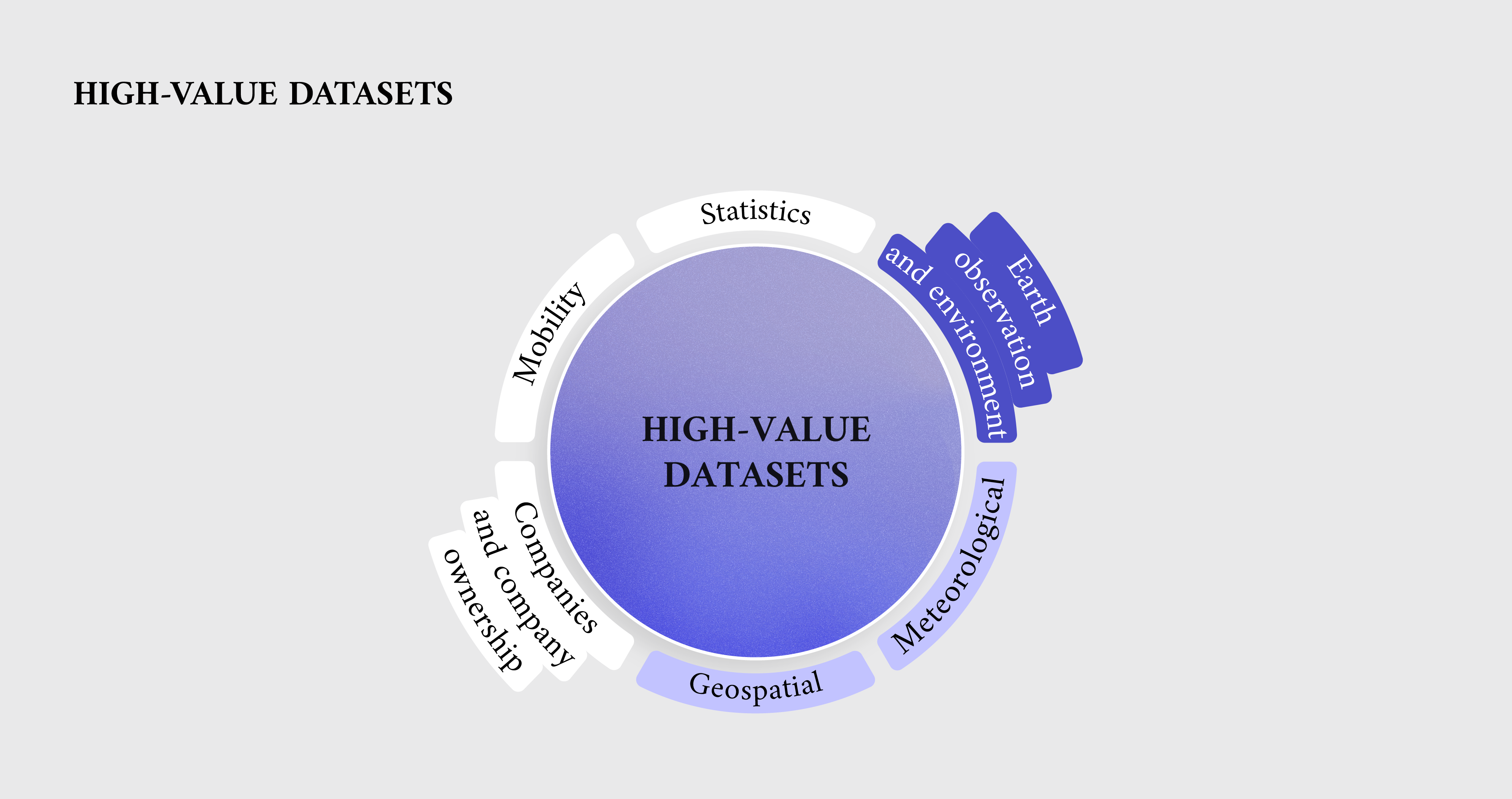
Data about forest fires come from multiple sources and fall under several high-value datasets’ thematic categories. Data on forest fires provided by the satellites of the Copernicus programme are part of the orthoimagery theme of the INSPIRE directive, which covers georeferenced image data of the Earth’s surface from either satellite or airborne sensors. Orthoimagery is included in the ‘Earth observation and environment’ high-value datasets thematic category, which consists of environmental information about air, climate and emissions, such as observation data by weather stations and climate data. Moreover, parts of the data fall under the ‘Geospatial’ category, which comprises administrative units, buildings and geographical names. Lastly, other datasets fall under the ‘Meteorological’ thematic category, which contains information such as climate data, weather alerts and weather station observation data. The high value of these datasets was assessed as per their impact on addressing pressing environmental or economic questions. For example, the damage assessment information provided by the Copernicus programme can quickly help establish the extent of the damage caused by fires.
Forest fires in the EU
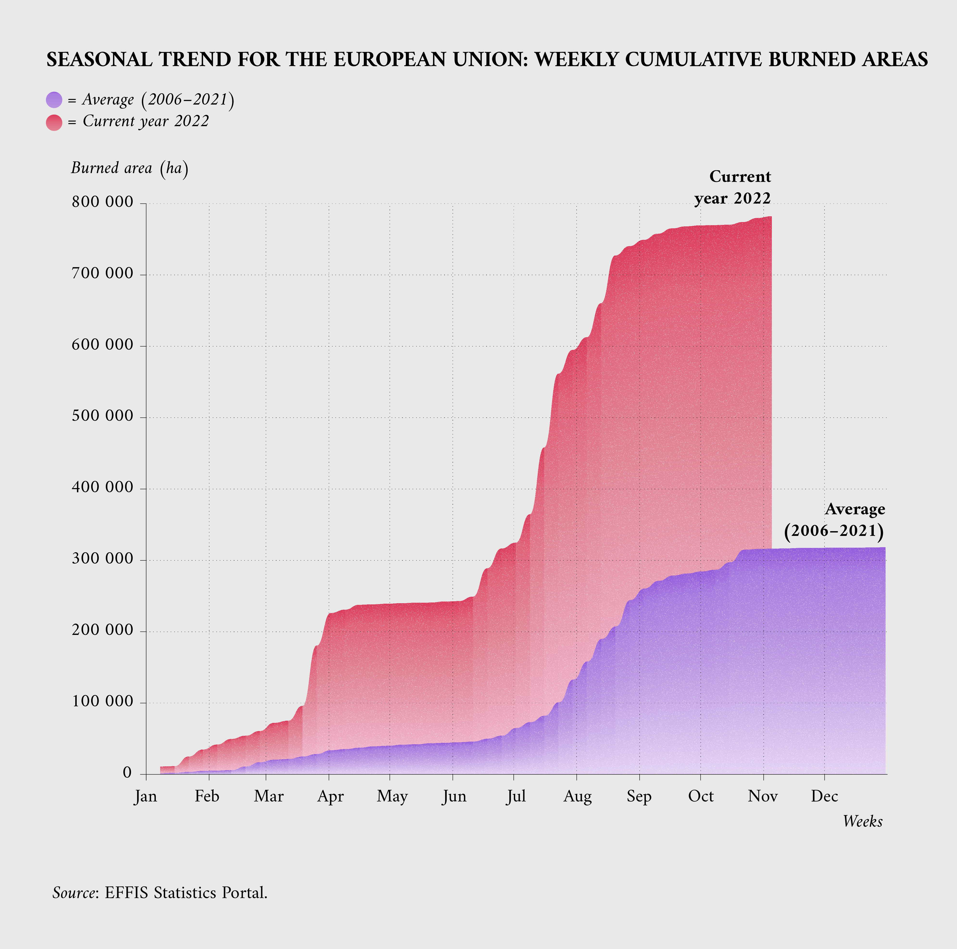
When it comes to forest fires, the 2022 summer was the worst year on record in the EU since 2006, as shown by the data from the European Forest Fire Information System (EFFIS). The cumulative burned area was almost three times more than the 2006–2021 average, with roughly 7 500 square kilometres burned – a little more than a third of the total surface area of Wales – compared to an average of 2 600 square kilometres in past summers.
Forest fires through EFFIS and Copernicus data
For a bird’s eye view of forest fires, EFFIS is a particularly valuable data source. Supported since 1998 by an international group of experts, EFFIS became one of the components of the emergency management services in the EU Copernicus programme in 2015. EFFIS offers several services, which, among other things, allow users to view the current situation in a map, read a curated list of news stories about fires, view long-term fire weather forecasts and access a detailed statistics portal. The portal offers estimates about burned areas and the number of fires, and seasonal trends that allow the reader to compare different time periods. Information is shown via charts and tables and can be directly downloaded in CSV and JSON formats.
EFFIS is one of the components of the Copernicus programme, a project implemented by the European Commission with support from the European Space Agency and the European Environment Agency. Copernicus operates through a set of dedicated satellites and their data are complemented and validated with on-the-ground information.
One of its services is called the Copernicus emergency management service (EMS), which uses satellite imagery and other geospatial data to provide mapping in the event of natural disasters, humanitarian crises or other emergencies. EMS is a service of specific interest for forest fires, as it can be triggered by authorised subjects (such as EU Member States, the Commission and others) and produces information in days or even within hours.
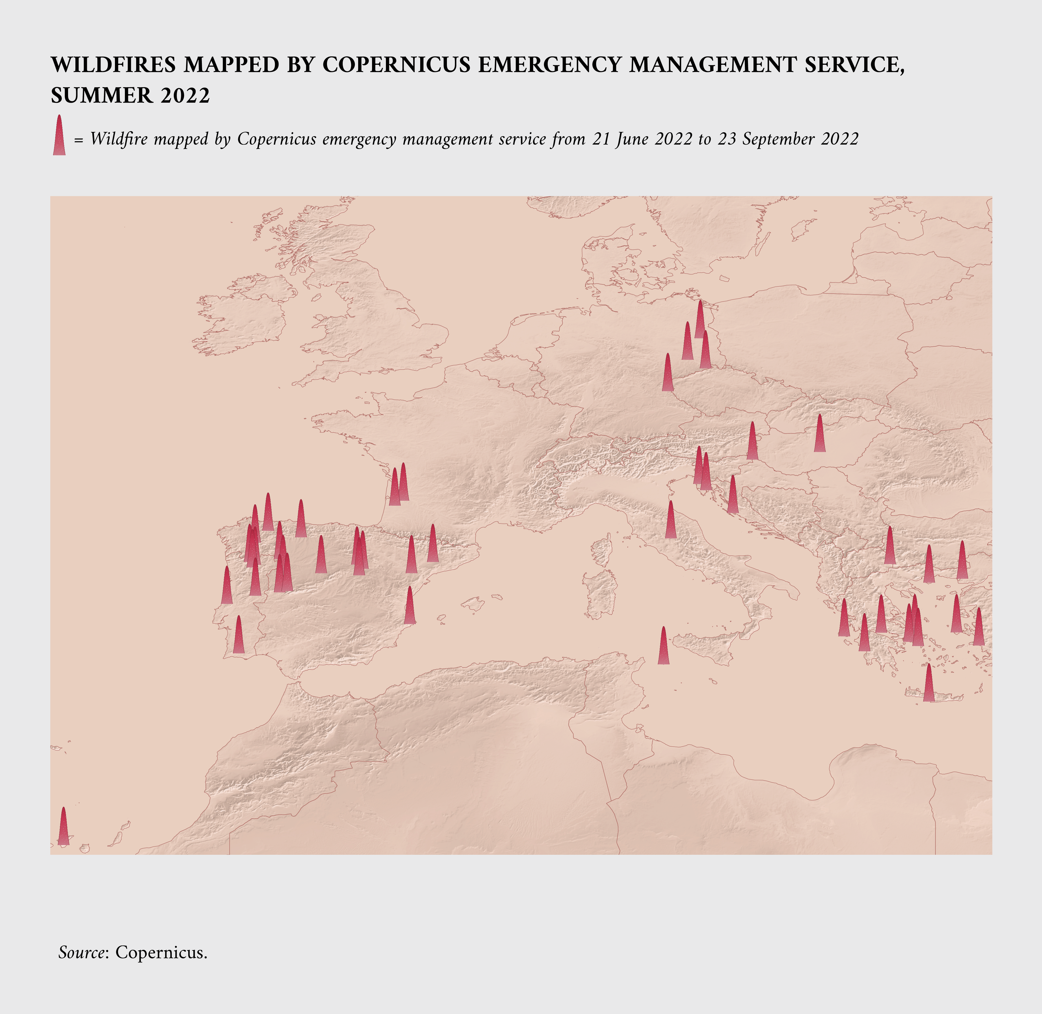
EMS is also used to provide estimates on the severity of damages caused by an event with a granularity up to singular infrastructure and building. The capabilities of the project are shown in the following visualisations. The following maps the areas where the EMS service was activated because of a wildfire or forest fire during the 2022 summer.
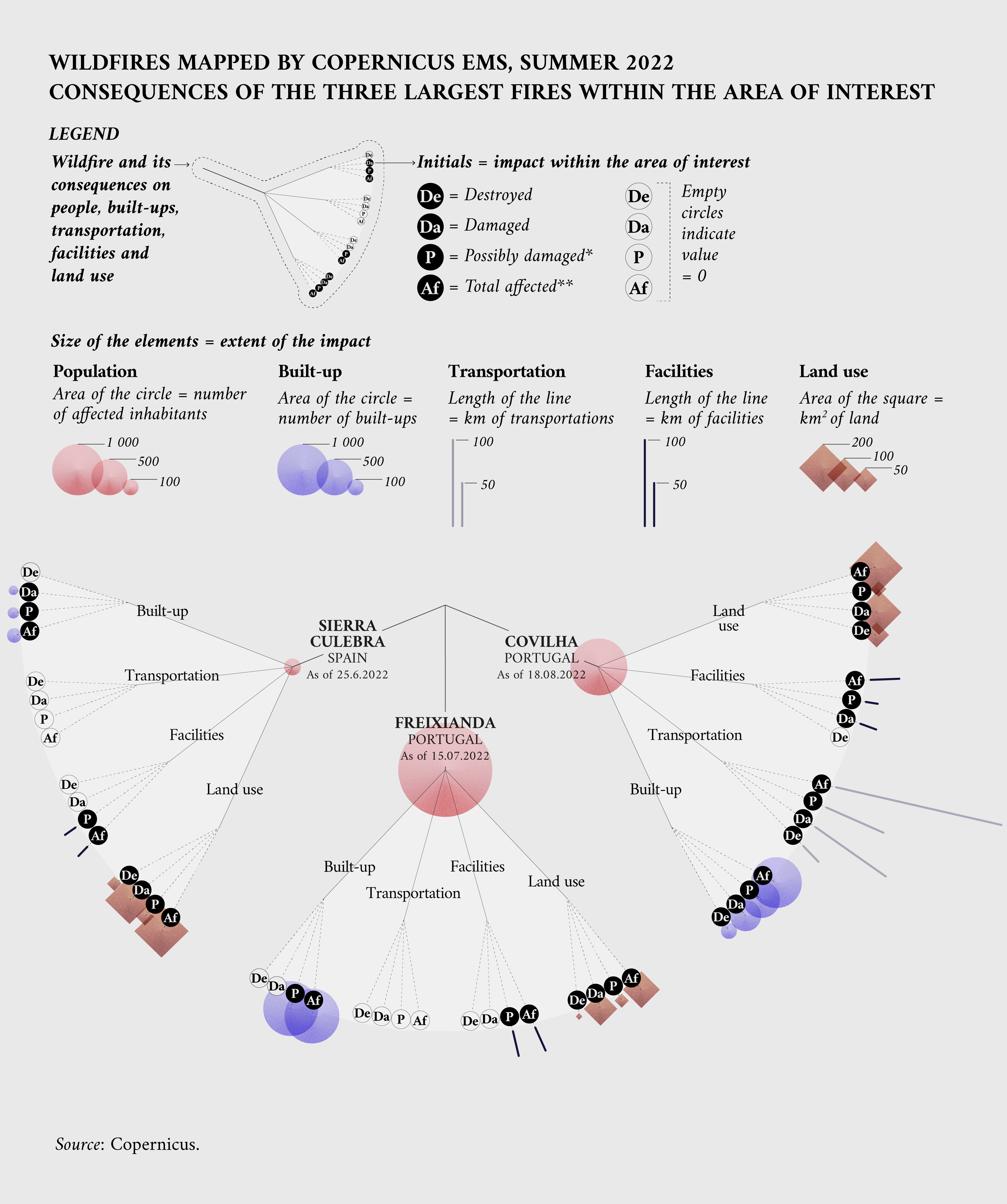
The EMS service also allows the affected areas to be observed in great detail and provides a series of maps that include estimates of the damage endured. The following visualisation shows three of the largest forest fires monitored by the EMS service that occurred in the EU during the summer of 2022, along with the damages dealt to nature and properties surrounding the events.
Forest fires data on data.europa.eu
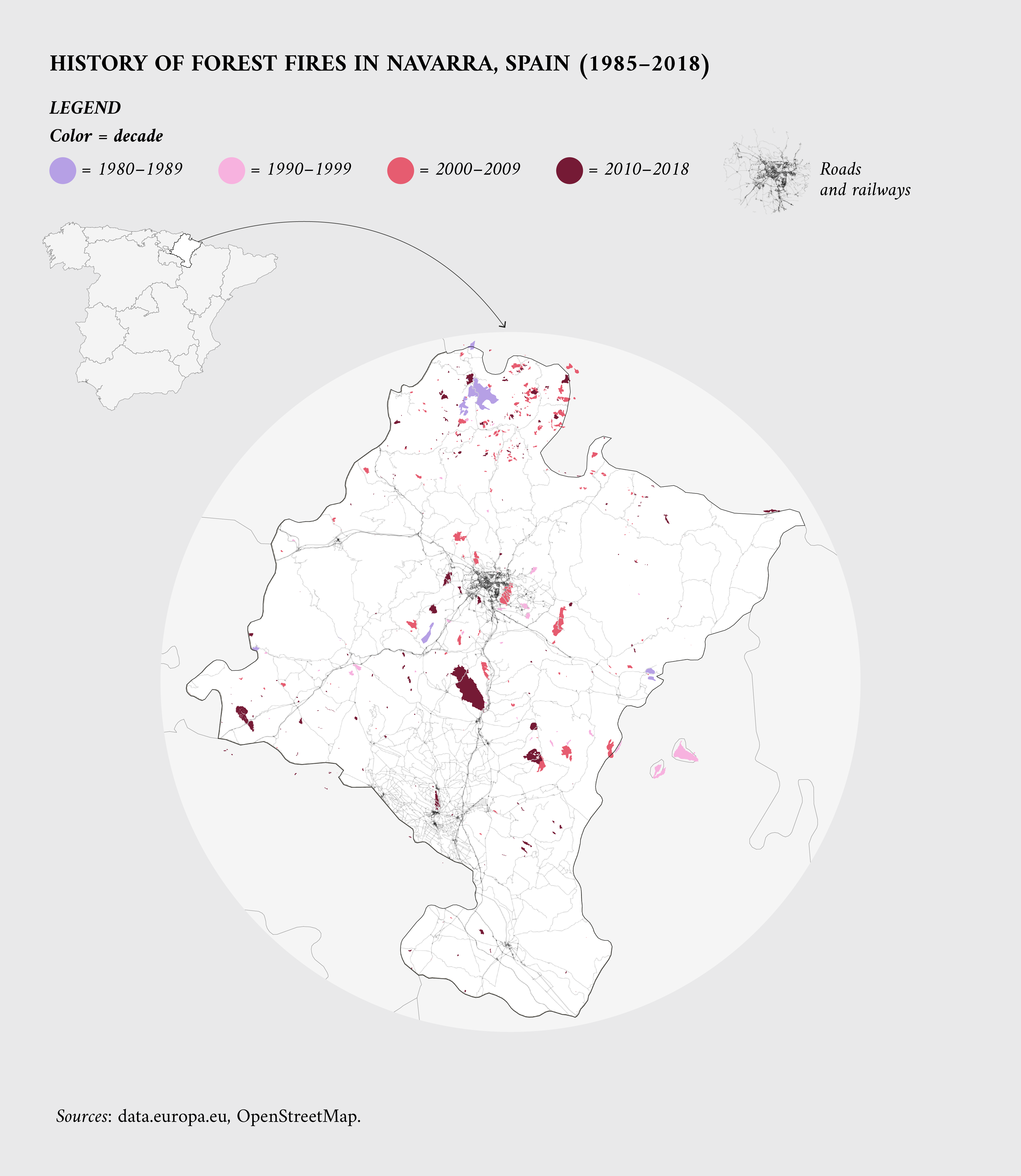
Another significant data source is data.europa.eu, the official portal for European data. A search performed in November 2022 showed over 3 000 results for the keyword ‘forest fires’, with datasets about a wide range of topics: penalties for forest fires in Italy, forest fires hazards in parts of Germany, along with a list of fires in Latvia or in the Navarra region (Spain) since 1985.
The following visualisation shows where and when forest fires occurred in the Spanish region from 1985 to 2019, along with some of their characteristics. The Department of Rural Development and Environment of Navarra is responsible for the collection of these data.
Other data sources on forest fires
More comprehensive information about forest fires can be found in reports that analyse this issue from different vantage points. EFFIS has a specific section on its website in which readers can find annual reports, forest fires studies done under the forest focus regulation (Regulation (EC) No 2152/2003) and country and regional maps.
Other reports are produced by the Joint Research Centre, the Commission’s science and knowledge service. One of those is an annual overview of the evolution and impact of wildfires in Europe, the Middle East and North Africa. The Joint Research Centre also hosts the global wildfire information system service, a real-time map based on NASA and Copernicus data.
The European Environmental Agency website has a section about forest fires. Based in part on EFFIS data, it also offers an analysis of the future forest fires danger under different climate change scenarios.
Copernicus also offers information about this topic. Its European State of the Climate report is a yearly analysis of climate conditions and events, from temperatures to precipitations, river discharges and, of course, wildfires.
Conclusion
According to a report from the Intergovernmental Panel on Climate Change, a body of the United Nations, ‘climate change is playing an increasing role in determining wildfire regimes alongside human activity, with future climate variability expected to enhance the risk and severity of wildfires in many biomes such as tropical rainforests’. This makes it of the utmost importance to monitor and assess the situation using all useful sources.
In this context, there is a clear need for free of charge, publicly available and reusable information. The identification of ‘Earth observation and environment’ as a key category of interest for high-value datasets is in line with this urgency. Since data need to comply with specific technical characteristics, EFFIS is an important case study as it favours data reuse through directly downloadable content and machine-readable formats. Moreover, the variety of datasets presented from the Copernicus programmes and data.europa.eu highlight the variety of data formats and sources available to users, enabling singular events and historical records to be analysed in great detail.
Methodological notes
The second visualisation lists cities that had a recorded activation of the Copernicus EMS system during the 2022 summer. Not all wildfires lead to an activation of the service, so this is a subset of the total number of events.
The data used in the third visualisation are about the three largest forest fires, by burned area, as recorded by Copernicus activation during the summer of 2022. Detailed information about those events is available on their activation page on the Copernicus website here, here and here.
To download the visualisations, click on the following: HVD overview, seasonal trends, wildfires summer 2022, wildfires impact, forest fires history.
To download the data behind the visualisations, click on the following: forest fires data
Article by Davide Mancino
Data visualisations by Federica Fragapane
